


Greater Cairo
Greater Cairo
Greater Cairo is the metropolitan area of three governorates - Cairo, Giza and Qalyubia.
It also emcompasses Helwan and 6 October. The total population of the metropolitan area according to some estimates is approxiately 30 million people.
Cairo stands on both banks of the River Nile in northern Egypt, immediately south of where the river flows out of the valley. It is surrounded by desert and is divided into the sections, forming the Nile Delta.
The old town is located on the east bank of the River. From the west of the city, the areas were modeled on Paris. There are wide boulevards and a few relatively small parks.
In the heart of Cairo in the middle of the Nile is located the quiet green island of Gezira / Zamalek. Here you will find expensive private villas, many embassies, offices reoresenting foreign companies, modern buildings and several five star hotels.
The old eastern part of the city is very diverse. For centuries it was built up haphazardly and here you will find narrow streets and crowded apartment buildings.
In contrast to western Cairo that has mostly government buildings and modern architectural buildings, the eastern part has hundreds of old mosques.
Cairo is located at a latitude of about 30 degrees to the north of the equator and is located on the southern boundary of the subtropical zone. Winter is warm and summer is hot. The temperature often exceeds 40 degrees. Winter temperatures usually exceed 20 degrees during the day but are colder at night and fall to about 10 degrees. Since the city is near the Sahara desert, rainfall is very rare, but if it rains it is very intense and can cause floods.
#LISA
Login/Registration
Weather in:
Exchange Rates
1 USD = 16.200 LE
1 EUR = 18.040 LE
Region news
-
WinDoorEX Middle East 2012 in Cairo
Apr 11, 2012, rating: 5.000, 9 votes The profile for exhibits at WinDoorEX Middle East 2012 includes PVC Window Systems...
-
Ten Kuwaiti lawyers to help defend Egypt's Mubarak
Sep 04, 2011, rating: 0.000, 0 votes The Kuwaitis will be coming on board for the third session of his trial scheduled for Monday, MENA said without ...
-
Egypt: Arab League to Launch First Global Real Estate Bourse
Mar 11, 2011, rating: 0.000, 0 votes Cairo news: The Arab League Secretariat General announced Thursday that it would launch its first Global real estate bourse with ...
-
Japan Finances Rural Income and Economic Enhancement Project in Egypt
Jan 16, 2011, rating: 0.000, 0 votes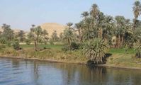 Egypt’s International Cooperation Minister Fayza Abul-Naga signed thethird and last grant for the Rural Income and Economic Enhancement Project ...